Surrey Hills AONB Boundary Review

Surrey Hills AONB: Boundary Variation Project

The following document has been submitted by West Horsley Parish Council to Natural England in response to the Statutory Consultation on its 'Surrey Hills AONB: Boundary Variation Project' report.


WHPC Submission to the AONB Boundary Review - June 2023


AONB Review Consultation (closes 13th June 2023)

West Horsley Parish Council made its submission to the initial call for evidence in January 2022, when the West Horsley area was classified as a suitable ‘Area for Evaluation’’ regarding an extension of the existing boundary of the Surrey Hills AONB.

In February 2023 Natural England, who is running the consultation process, announced that there will be a 14-week ‘Statutory Consultation’ period ending on June 13th during which consultees can make further comments.

Having studied the submissions, the draft proposal for ‘Candidate Areas’, i.e. areas which they are recommending for inclusion, was published and it appears that West Horsley has now been excluded (see map). However, this is only an initial recommendation and following the consultation there may well be alterations and anomalies – for example Natural England has included the Hatchlands Estate in their new boundary but excluded West Horsley Place, which seems to be curious logic. Interestingly, in their documentation they used a picture of West Horsley Place as an example of a historic Surrey Hills building but incorrectly labelled it Hatchlands, so it appears that nothing is yet finalised!

West Horsley Parish Council will be objecting to the draft boundary extension and submitting a counter proposal for at least the inclusion of the West Horsley Pace estate and will be working closely with Natural England (NE) to try and achieve a positive result.

Residents are encouraged to submit comments by June 13th.

Details of how to respond to the consultation can be found at Surrey Hills Area of Outstanding Natural Beauty Boundary Variation Project - Defra - Citizen Space.

More information can also be read at Views sought on extending protected Surrey area - GOV.UK (www.gov.uk)


The area now being considered for inclusion in the AONB is called 'Hatchlands & Clandon'.

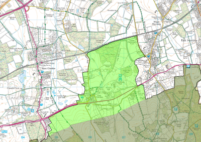
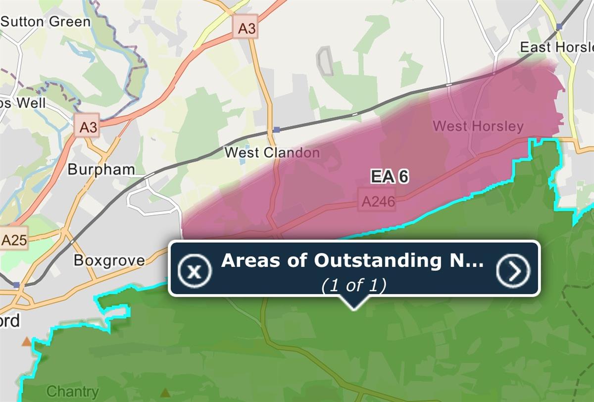
West Horsley was originally included in Evaluation Area 6  (see map below).


West Horsley Parish Council's submission to the Boundary Review 

Published: 28 January 2022

The following document has been submitted by West Horsley Parish Council (WHPC) as part of the Surrey Hills 'Call for Evidence' on the potential for expanding the area designated as AONB (more specifically Evaluation EA6).

WHPC Submission to the Surrey Hill AONB Boundary Review - January 2022

Anyone can participate in this initial 'call for evidence' stage of the boundary review, however time is running out as the deadline is Monday, 31st January 2022. For more information, and to be part of this important process, go to Surrey Hills AONB Boundary Review - Share.


Surrey Hills AONB Boundary Review Call for Evidence 

Posted: 22 December 2021

West Horsley Parish Council is currently collating evidence to support the extension of the Surrey Hills AONB Area to include much of the Parish (see map). Our evidence will be submitted before the closing date, which is 31st January 2022.

It is really important for as many people as possible who live in and around the area to participate in this review process. Please contribute your knowledge and impressions of the landscape in the Evaluation Area. Where there is a particularly strong case for consideration, landscape immediately next to the Evaluation Area will also be considered.

Natural England is asking everyone to gather information about the natural beauty of the landscape, its condition, scenery, wildness, tranquillity, natural and cultural heritage. Evidence that you can provide for these factors will be particularly important for its assessments.

For further information please visit the Surrey Hills AONB Boundary Review website.

Evidence can be submitted via the website or via email at evidence@surrey-hills-aonb-boundary-review.org.

Please submit your evidence by 31st January 2022, and if possible, share with the Parish Council at clerk@westhorsley.info.

Map shows Evaluation Area 6: incorporating land from Bushy Hill through to East Horsley (including large parts of West Horsley)